Liptov
Liptov is a region in Central Slovakia.
Cities
- 🌍 Liptovský Hrádok.

.svg.png)
- 🌍 Liptovský Mikuláš. A good starting point to Western Tatras, Choč Mountains and Low Tatras.
- 🌍 Ružomberok. A good starting point to Western Tatras, Low Tatras, Choč Mountains and Great Fatra. Skiing right in a suburb of the city. Likava castle in a village nextdoor.
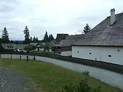
Villages
- 🌍 Vlkolínec. A UNESCO listed example of traditional architecture.
- 🌍 Východná. A place of yearly folklore fest.
- 🌍 Liptovská Osada. Hiking and relaxation inbetween mountains.
Other destinations
- 🌍 Liptovská Mara dam. The biggest water reservoir in Slovakia and a popular recreational site. The surroundings of the dam offers many cultural, spa and water activities.
Mountain ranges:
- 🌍 Western Tatras. Hiking and skiing.
- 🌍 Low Tatras. Endless hiking possibilities, skiing, one of the most visited caves in Slovakia.
- 🌍 Choč Mountains. Pretty ravines and great overview from the top of the main mountain.
- 🌍 Great Fatra. Hiking.
Understand
History
The first known inhabitants came to Liptov during the Neolithic age around 6000 years ago. Celts represent an important time period of Liptov during the Iron Age. The Celtic tribal village can be seen in the archeological site of Havránok near Liptovský Mikuláš.
The first settlements of Slavic people in Liptov region began approximately in the 6th century BC. The first written evidence about Liptov came from 1231 AD.
There are three remains of castles that were built in the Liptov region. They are the Likava castle, the Liptov castle, and the Liptovský Hrádok castle. Liptov is also a place where the legendary Slovak figure of the 17th and 18th centuries, Juraj Jánošík, was sentenced to death.
Geography
The region is surrounded by multiple mountain ranges.
The longest Slovak river Váh flows through it and fills the important water reservoir Liptovská Mara - which functions both as a water electric power facility and recreational area. There were multiple villages in place of the reservoir, buildings of which are new preserved/moved to open air Liptov village muzeum in Pribylina.
Get in
Trains and interstate buses go to the major cities from east to west.
The smaller villages in general have public inter-city bus connections available.
Get around
Public transport is pretty well organized in the area, although sometimes the time schedules are sparse (some villages only few times a day).
See
There are multiple caves in the area - Demänovská Cave of Liberty, Demänovská Ice Cave (at Low Tatras) and Važecká Cave (Važec).
- 🌍 Liptov village museum (in Pribylina). A reconstruction of a historical village destroyed while creating Liptovská Mara dam.
- 🌍 Havránok (On the road around Bešeňová from Ružomberok), ☏ +421 44 432 24 68. A Celtic archeological site with a small museum.
Do
Ski areas include:
- Jasná -- detailed in Low Tatras
- 🌍 Malinô Brdo (In Ružomberok).
- Donovaly, at the edge of Liptov.
Water parks near Liptovský Michal.
Eat
Drink
Stay safe
The cities and especially villages are generally safe - but compared to northern countries, it's not recommended leaving cars unlocked and similar.
Go next
Nearby regions: Culturally similar Orava, Spiš - and Banská Bystrica on the south.