Confederate States of America
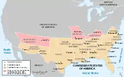
The Confederate States of American, also called the Confederacy, was the government created by 11 Southern States who seceded from the Union (or United States) between 1860 and 1861. They wanted to form their own country, one in which slavery was legal.[1] Jefferson Davis was elected president.[2] The Confederacy claimed 13 states. But the states of Kentucky and Missouri never seceded from the Union and were never controlled by Confederate forces.[3] The United States never recognized the Confederate States of America as a legitimate government.[4] The American Civil War was fought over their right to secede and at the end of the war they were admitted back into the Union. No foreign country ever recognized the Confederacy.
Capitals
The first capital of the Confederacy was Montgomery, Alabama.[5] In early February, 1861, the convention that formed the Confederacy met there. But by early summer, the heat and humidity of Montgomery as well as the mosquitos made many change their minds.[5] Virginia had just seceded and offered their state capitol, Richmond, as the capital of the Confederacy. The offer was gladly accepted.[5] It remained the capital until 1865. After the fall of Richmond, on April 3, 1865, Jefferson Davis and the government fled the city.[5] They traveled to Danville, Virginia. It was the capital of the Confederacy for only eight days (April 3–April 10).[5]
References
- ↑ "Confederacy". HistoryNet. http://www.historynet.com/confederacy. Retrieved 4 July 2016.
- ↑ "Jefferson Davis Elected President of the Confederate States of America November 6, 1861". The Library of Congress. http://www.americaslibrary.gov/jb/civil/jb_civil_davis_1.html. Retrieved 4 July 2016.
- ↑ William E. Gienapp. "Abraham Lincoln and the Border States". Journal of the American Abraham Lincoln Association. University of Michigan Library. http://quod.lib.umich.edu/j/jala/2629860.0013.104/--abraham-lincoln-and-the-border-states?rgn=main;view=fulltext. Retrieved 4 July 2016.
- ↑ "Confederate States of America". American History. Legends of America. http://www.legendsofamerica.com/ah-confederatestates.html. Retrieved 4 July 2016.
- 1 2 3 4 5 "Capital Cities of the Confederacy". Civil War Trust. http://www.civilwar.org/education/history/warfare-and-logistics/logistics/capital.html. Retrieved 4 July 2016.
Other websites
- The Confederate States of America; Fact Monster
- The Confederate States of America's Flag and its Story; YouTube